hiking trails
 t-shirts etc.
 maps/guides
 daytrips
 fishing
 SCE directory
 
map
 advertise
 
home


Find our FREE trail descriptions useful?

 
Great Sand Dunes National Monument

Directions: From Silverthorne take I-70 west to exit 203 (Frisco/Breckenridge). Take route 9 south to Fairplay where you stay straight at the intersection onto Rt. 285 which continues for 82 miles
to route 17. You take a slight left onto route 17 and take a left onto Six Mile Lane Rd.as you come in to Mosca. Six Mile Lane Rd. leads to the Great Sand Dunes National Monument and the visitors center. The total distance from Silverthorne is about 170 miles with a driving time of about three hours.
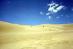
The Great Sand Dunes National Monument is a geologic wonderland that consists of North America's tallest sand dunes that rise over 700' against the rugged backdrop of the awe inspiring Sangre de Cristo
Mountains.  Thirty nine square miles of dunes backed by six peaks over 13,000"  provide some of Colorado most unique hiking opportunities as well as spectacular scenery. People from all over come to hike, camp, and sled down the steep dunes with make shift sleds and snowboards!


Below: A SCE staff member down in the dunes


For those planning a trek over the dunes, it is best to avoid the mid-day heat in the summer months and to take plenty of water. For detailed information on the dunes click the link here!.
 

Left: It gets HOT here!  Very similar to a very hot day at the beach with NO ocean to cool off in!


    fun family day trips   historical and fun day trips   scenic wonders - day trips
    Mount Evans   Leadville Colorado   Royal Gorge
    Country Boy Mine   Georgetown Loop   Maroon Bells
    St. Mary's Glacier       Great Sand Dunes


map | hiking trails | fishing | daytrips | submit a hike | hiking maps/guides
SCE gear | sc directory | link us | home
| contact us | ad rates


Note: The Summit County Explorer website is for entertainment purposes only. SCE will not be held liable for the any accidents or injuries resulting from the activities listed on this site. Trail conditions change daily and we assume no responsibility for the safety of any individual during any of these activities. Please consult actual trail guides and maps before attempting any of the activities mentioned here.