hiking trails
 t-shirts etc.
 maps/guides
 daytrips
 fishing
 SCE directory
 
map
 advertise
 
home


Find our FREE trail descriptions useful?


 Mesa Cortina Trail

Length: 5.2 miles (round-trip)
Highlights: 
Spectacular aspen and lodge pole forest, sage brush meadows,
views of Lake Dillon, Ptarmigan Peak and the Williams Fork Mountains.


Difficulty Rating:
Beginner
Elevation Gain: Approx. 400 ft.
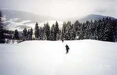
Below:  Snowshoeing through an open field prior to entering the forest

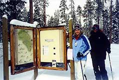
Directions: Take Colorado 9 north from the Silverthorne exit (205) of I-70. Turn left onto Wildernest Road at the traffic light - A Wendy's is located on the right and a 7-11 store on your left. As you start up the mountain Wildernest Road becomes Ryan Gulch Road. Look for Buffalo Drive on your right and turn right here. Buffalo Drive dead ends at Buffalo Mountain Drive and you will turn right here. Take the next left, Lakeview Drive, which is soon intersected by Aspen Drive. Turn left onto Aspen Drive and the parking lot for the trailhead will be on your right.
 
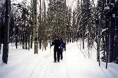
Description:
The Mesa Cortina Trail is a hike for all seasons and ages! Wildflowers in June, golden aspen in the fall, and the quiet beauty of snow covered peaks and meadows in winter amply attest to this trail's year round appeal.


 Below: SCE Explorers pause for a snapshot marking the trailhead.


From the trailhead a 20 or 25 minute walk brings you to a sign marking
the entrance to the Eagles Nest Wilderness. Soon, you begin the most
difficult part of the hike by ascending a series of switchbacks through
the forest. Here you will enjoy opportunities for views of Lake Dillon
off to the south and glimpses of the snow capped Williams Fork Mountains to the northeast.

(A copy of the "Summit, Vail and Holy Cross Trail Map," available form Weber's Books, is helpful in finding landmarks.)

At about 2.1 miles the trail merges with an old ranching road that comes in from
the right (east).

Another half mile brings you to a crossing of South Willow Creek where a sign marks the merger with the Gore Range Trail.


Above: SCE explorers traversing on snowshoes through the woods

Above:  Our goal for the day - the sign marking the Gore Range Trail.


On this particular outing, the Mesa Cortina trail provided the Summit County Explorers
with a tranquil setting for lunch and relaxation before retracing our steps back to the trailhead.


Check out Summit County Explorer's
"I LIKE TO BE ON TOPTM"
T-shirt and gear!

Click logo above


Above: South Willow Creek covered in deep fresh snowfall.


  beginner intermediate advanced
    Black Powder Pass   Mohawk Lake   Quandary Peak  14,265'
    Lily Pad   Chihuahua Gulch   Lincoln & Bross 14,291' / 14,177'
    St. John's   Mt. Royal   Bierstadt Peak 14,060'
    Mayflower Gulch   Wheeler Lakes   Willow & Salmon Lakes
    Loveland Pass   Radical Hill Trail   Upper Crystal Lake
    Salt Lick Trail   McCullough Gulch   Gray's & Torrey's 14,278' / 14,267'
    Mesa Cortina Trail   Mt. Sniktau   Mt. Democrat 14,152'
    St. Mary's Glacier   North Ten Mile Trail   Mt. Victoria
    Sally Barber Mine   Willow Falls  

Mt. Elbert  14,433'

    Oro Grande Trail   Eaglesmere Lakes   Buffalo Mountain  12,777'
    Meadow Creek-Salt Lick   Mosquito Pass   Eccles Pass
    Shrine Mountain Trail   Webster Pass   Mt. Huron  14,003'
    Ptarmigan Trail   Ptarmigan via Wilder Gulch    
    Peaks Tr. Barton Gulch   Wheeler Lake - Park County    
    Hoosier Pass Loop   Lenawee Trail    


  Spruce Creek Loop NEW! Nightmare on Baldy Mine    
  NEW! Tenderfoot Mountain Trail        
   

Did You find our FREE trail descriptions useful?
Please donate a buck or two. We appreciate your support!


map | hiking trails | fishing | daytrips | submit a hike | hiking maps/guides
SCE gear | sc directory | link us | home
| contact us | ad rates


Note: The Summit County Explorer website is for entertainment purposes only. SCE will not be held liable for the any accidents or injuries resulting from the activities listed on this site. Trail conditions change daily and we assume no responsibility for the safety of any individual during any of these activities. Please consult actual trail guides and maps before attempting any of the activities mentioned here.