|
|
 |
 
|
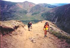
Below:
The last climb approaching the top of radical hill. In the
background note the 12,800' Red Cone and the zig-zagging trail
leading up to Webster Pass |
|
|

|
|
At the fork, bear right and begin
your ascent of Radical Hill to an elevation of about 12,500
feet. If you don't mind the roar of an occasional motocross bike
or the inconvenience of dodging a rare jeep or hummer, you will
be treated to rewarding views the entire length of your hike. To
the east you will see Webster Pass and 12,800' Red Cone. The
alpine tundra exhibits beautiful meadows of wildflowers
throughout the summer.
About a half mile from your destination, just before beginning a
series of switchbacks to the top, you pass the remains of an old
mining cabin perched on a ledge. |
|
 |
The views here provide an opportunity to
pause and refresh before beginning your assault on the summit.
On a warm July day, with threatening thunderclouds on the
horizon, SCE staffers were privileged to enjoy the company |
|
|
Check out Summit County Explorer's
"I LIKE TO BE ON TOP"
T-shirt and other gear!
Click logo above |
|
|
|
|
|
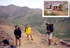
Above:
During our climb, the SCE staff experienced multiple changes in
weather, from beautiful sunshine, to hail, to lightning storms.
We took refuge from the lightning in the cabin on our descent
(inset). Please note: Batteries are not included with the
glowing yellow raingear! (SCE member in the center) |
|
|
|
|
|
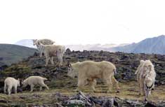 |
of numerous mountain goats casually
grazing on the tundra.
Although our stay was shortened by
approaching lightning, their presence provided just one more
reason why SC Explorers "like to be on top"! |
 |
|
|
|
|
At the
top, we had the fortunate experience of running into may
mountain goats,
with their playful young bounding around like popcorn! |
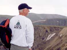
SCE
staff member posing in a now famous "I like to be on top"
sweatshirt. |
|
|
|
|
|
|
|
|
|
|

|
beginner
|
|
intermediate
|
|
advanced
|
|
|
|
Black
Powder Pass
|
|
Mohawk
Lake
|
|
Quandary
Peak
14,265' |
|
|
|
Lily
Pad
|
|
Chihuahua
Gulch
|
|
Lincoln & Bross
14,291' / 14,177' |
|
|
|
St.
John's
|
|
Mt.
Royal
|
|
Bierstadt Peak
14,060' |
|
|
|
Mayflower Gulch |
|
Wheeler Lakes |
|
Willow & Salmon Lakes |
|
|
|
Loveland Pass |
|
Radical Hill Trail |
|
Upper Crystal Lake |
|
|
|
Salt Lick
Trail |
|
McCullough Gulch |
|
Gray's & Torrey's
14,278' / 14,267' |
|
|
|
Mesa
Cortina Trail |
|
Mt.
Sniktau |
|
Mt. Democrat
14,152' |
|
|
|
St. Mary's Glacier |
|
North
Ten Mile Trail |
|
Mt.
Victoria |
|
|
|
Sally Barber Mine |
|
Willow
Falls |
|
Mt.
Elbert
14,433' |
|
|
|
Oro
Grande Trail |
|
Eaglesmere Lakes |
|
Buffalo Mountain
12,777' |
|
|
|
Meadow Creek-Salt Lick |
|
Mosquito Pass |
|
Eccles Pass |
|
|
|
Shrine Mountain
Trail |
|
Webster Pass |
|
Mt. Huron 14,003' |
|
|
|
Ptarmigan Trail |
|
Ptarmigan via Wilder Gulch |
|
|
|
|
|
Peaks Tr. Barton Gulch |
|
Wheeler
Lake - Park County |
|
|
|
|
|
Hoosier Pass Loop |
|
Lenawee
Trail |
|
|
|
|
|
Spruce Creek Loop |
NEW! |
Nightmare on Baldy Mine |
|
|
|
|
NEW! |
Tenderfoot
Mountain Trail |
|
|
|
|
|
|
|
Did You find our FREE trail descriptions useful?
Please donate a buck or
two.
We appreciate your support! |
 |
|
|
|
|
|
|
|
|
|
|
|
|
|


