|
|
 |
|
Below:
Gore range trail junction about 2 3/4 miles from the Mesa
Cortina Trailhead. |
|
|

|
|
|
Description:
This hike is looong and involves a significant
elevation gain but the rewards are indescribable - kind of like the
soreness you will feel the next day if you are not in shape!!
Beginning at the Mesa Cortina trailhead you
enter the Eagles Nest Wilderness after about a twenty minute walk
and begin ascending a series of switchbacks through the forest.
Views of Lake Dillon canbe glimpsed off to the south and the snow
capped (usually) Williams Fork Mountains off to the northeast can
provide a pleasant diversion. |

|
|
|
|
|
 |
After about two and a
half miles from the trailhead you will cross South Willow Creek and
see a sign that marks the merger with the Gore Range Trail. Turn
right (north) here and follow the the Gore Range Trail for about
three and a half miles and numerous stream crossings until you reach
the junction with Willow Lakes Trail.
Follow this Trail for
about another two miles, numerous switchbacks and an 800� elevation
gain to the Salmon Lake Trail which appears on your right. |
Below:
Willow Lakes Trail
Junction about 6 and a half miles from the Mesa Cortina
Trailhead.
 |
|
Above: Great views of the Gore Range as you head toward the
junction with the Willow Lakes Trail. |
|
|
|
|
 |
A steep ascent of several hundred yards brings you to the
spectacular Salmon Lake at about 11,165'.
Trace your steps back to the trail
intersection and sign. Hang a right there, and follow the trail back
to the Willow Lakes area. |
 |
|
Above:
View from the Willow Lakes Trail. |
Above: Sign marking trail up to Salmon Lake |
 |
You will cross two streams before coming
to the first of three Willow Lakes. If you go to all of the lakes it
will add at least another mile to your hike from Salmon Lake but is
well worth it. If you have your license and some equipment, try your
luck in Willow Lakes. We did and pulled out more than a dozen trout.
Your elevation at the last lake will be approx. 11,390'. |
 |
|
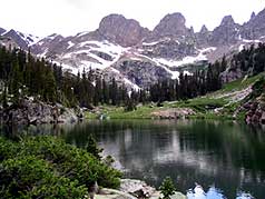
Above:
Destination # 1: Salmon Lake |
Above: Another shot of Salmon Lake |
 |
Spectacular views of Red Peak and the
saw tooth Gore Range abound throughout this hike making it one of
the most stunning wilderness experiences in Colorado.
Be sure to purchase a copy of the "Summit, Vail & Holy Cross" Trail
Map from Weber's bookstore on Main Street in Breckenridge before
heading into the backcountry!! |
 |
|
Above:
Another one of Willow Lakes |
Above: Scenery along the trail... between the lakes |
|
|
|
|
|
 
|
"I LIKE TO BE ON TOP"
t-shirt and other merchandise
Click logo at left! |
|
|
|
|
|
|
|
|
|
|
|
|
|
|

|
beginner
|
|
intermediate
|
|
advanced
|
|
|
|
Black
Powder Pass
|
|
Mohawk
Lake
|
|
Quandary
Peak
14,265' |
|
|
|
Lily
Pad
|
|
Chihuahua
Gulch
|
|
Lincoln & Bross
14,291' / 14,177' |
|
|
|
St.
John's
|
|
Mt.
Royal
|
|
Bierstadt Peak
14,060' |
|
|
|
Mayflower Gulch |
|
Wheeler Lakes |
|
Willow & Salmon Lakes |
|
|
|
Loveland Pass |
|
Radical Hill Trail |
|
Upper Crystal Lake |
|
|
|
Salt Lick
Trail |
|
McCullough Gulch |
|
Gray's & Torrey's
14,278' / 14,267' |
|
|
|
Mesa
Cortina Trail |
|
Mt.
Sniktau |
|
Mt. Democrat
14,152' |
|
|
|
St. Mary's Glacier |
|
North
Ten Mile Trail |
|
Mt.
Victoria |
|
|
|
Sally Barber Mine |
|
Willow
Falls |
|
Mt.
Elbert
14,433' |
|
|
|
Oro
Grande Trail |
|
Eaglesmere Lakes |
|
Buffalo Mountain
12,777' |
|
|
|
Meadow Creek-Salt Lick |
|
Mosquito Pass |
|
Eccles Pass |
|
|
|
Shrine Mountain
Trail |
|
Webster Pass |
|
Mt. Huron 14,003' |
|
|
|
Ptarmigan Trail |
|
Ptarmigan via Wilder Gulch |
|
|
|
|
|
Peaks Tr. Barton Gulch |
|
Wheeler
Lake - Park County |
|
|
|
|
|
Hoosier Pass Loop |
|
Lenawee
Trail |
|
|
|
|
|
Spruce Creek Loop |
NEW! |
Nightmare on Baldy Mine |
|
|
|
|
NEW! |
Tenderfoot
Mountain Trail |
|
|
|
|
|
|
|
Did You find our FREE trail descriptions useful?
Please donate a buck or
two.
We appreciate your support! |
 |
|
|
|
|
|
|
|
|
|
|
|
|
|