|

|
 |
|
Below:
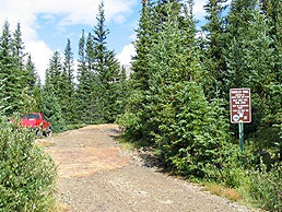
Just past Magnolia Mine a sign
marks the beginning of the Wheeler Trail |
|
|

Check out Summit County Explorer's
"I LIKE TO BE ON TOP"
T-shirt and gear!
Click logo above
|
|
Description:
You begin your hike by taking the
4wd road to Magnolia mine and following the Wheeler Trail
through Platte Gulch. The Wheeler Trail is really a 4x4
trail with challenging obstacles for four-wheel drive
enthusiasts. Normally, SCE members would have overlooked a hike
along this trail to avoid the congestion of recreational
vehicles, but a tip from the hostess at the Alma Coffee Shop
convinced us that there was an impressive view above Platte
Gulch culminating at Wheeler Lake that would be worth the trek.
Beginning above the Montgomery Reservoir, the
trailhead runs underneath an abandoned mine building at an
elevation of about 11,000 feet. |
|
 |
The trail is
rather rocky and occasionally it is necessary to bypass water
run-off which can accumulate into sizable water obstacles on
foot. Sturdy hiking shoes are suggested.
Although there are numerous obstacles for 4x4
enthusiasts, hiking the trail is not particularly difficult for
the first three mile(s).
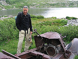
The freshly dropped transmission gear box we found lying in a
puddle along the trail suggests that the rock outcroppings are
far less forgiving of improperly equipped 4x4's than of hikers
seeking the beauty of the Pike National Forest between Mt.
Lincoln and North Star Mountain. |
 |
|
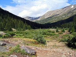
Above: Looking back Platte Gulch as the trail begins |
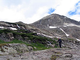
Above: about a half mile before the
lake the
final ascent begins |
 |
 |
|
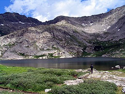
Above: final approach to Wheeler Lake |
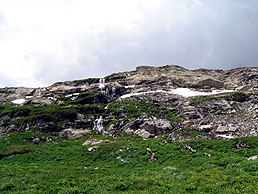
Above: falls at the top of the
ridge |
 |
Abandoned mines dot the landscape on
either side of the trail as you make your way deeper into the
gulch along the middle fork of the South Platte River. The
rock-strewn trail continues to follow the gulch while gradually
climbing above tree line to 12,200 feet. |
 |
|
Above: mining ruins at the far end of Wheeler Lake |
|
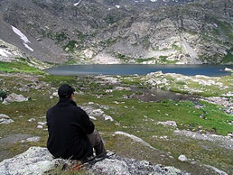
Above: finally - a little lunch
break at the top while enjoying the view |
|
|
|
|
|
After approximately three miles, the
trail begins a steeper ascent and eventually turns to the right
for a few switchbacks and the last uphill pull to the lake.
The hostess in Alma was right, a
spectacular view of Wheeler Lake in a bowl at the base of
Wheeler Mountain unfolds. Two waterfalls, abundant wildflowers,
rock outcroppings, abandoned mines, and the solitude of the lake
make this destination well-worth a visit. Looking back towards
the gulch and off to the right, ruins of an old mining community
await the eager explorer in Platte Gulch at the base of Traver
and McNamee Peaks. But for now, SCE members simply enjoyed the
lake views and strolled deeper into the bowl itself.
If you plan to hike this trail, get there
early. The longer the day progresses, the more you might find
yourself stepping aside to share the road with four-wheel drive
vehicles. After enjoying this view, the SCE crew recommend a
stop at the coffee shop in Alma to complete the experience. |
|
|
|
|
|
|
|
|
|
|
|
|
|
|

|
beginner
|
|
intermediate
|
|
advanced
|
|
|
|
Black
Powder Pass
|
|
Mohawk
Lake
|
|
Quandary
Peak
14,265' |
|
|
|
Lily
Pad
|
|
Chihuahua
Gulch
|
|
Lincoln & Bross
14,291' / 14,177' |
|
|
|
St.
John's
|
|
Mt.
Royal
|
|
Bierstadt Peak
14,060' |
|
|
|
Mayflower Gulch |
|
Wheeler Lakes |
|
Willow & Salmon Lakes |
|
|
|
Loveland Pass |
|
Radical Hill Trail |
|
Upper Crystal Lake |
|
|
|
Salt Lick
Trail |
|
McCullough Gulch |
|
Gray's & Torrey's
14,278' / 14,267' |
|
|
|
Mesa
Cortina Trail |
|
Mt.
Sniktau |
|
Mt. Democrat
14,152' |
|
|
|
St. Mary's Glacier |
|
North
Ten Mile Trail |
|
Mt.
Victoria |
|
|
|
Sally Barber Mine |
|
Willow
Falls |
|
Mt.
Elbert
14,433' |
|
|
|
Oro
Grande Trail |
|
Eaglesmere Lakes |
|
Buffalo Mountain
12,777' |
|
|
|
Meadow Creek-Salt Lick |
|
Mosquito Pass |
|
Eccles Pass |
|
|
|
Shrine Mountain
Trail |
|
Webster Pass |
|
Mt. Huron 14,003' |
|
|
|
Ptarmigan Trail |
|
Ptarmigan via Wilder Gulch |
|
|
|
|
|
Peaks Tr. Barton Gulch |
|
Wheeler
Lake - Park County |
|
|
|
|
|
Hoosier Pass Loop |
|
Lenawee
Trail |
|
|
|
|
|
Spruce Creek Loop |
NEW! |
Nightmare on Baldy Mine |
|
|
|
|
NEW! |
Tenderfoot
Mountain Trail |
|
|
|
|
|
|
|
Did You find our FREE trail descriptions useful?
Please donate a buck or
two.
We appreciate your support! |
 |
|
|
|
|
|
|
|
|
|
|
|
|
|


