|
|
 |
|
Below:
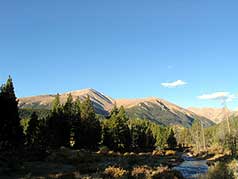
Early morning, on the road to the trail head - Mt. Elbert Peak
rises off in the distance. |
|
|

|
|
|
Summit County Explorers will acknowledge that
this hike is NOT in Summit County but let's face it, when the second
highest point in the continental U.S. (14,433 ft.) beckons just
south of Leadville, who can resist the temptation to find out what
it is like to "be on top"? The trail is
well marked all the way to the summit BUT a 4,700 elevation gain
over a distance of more than four miles, some through steep talus,
will test your determination and conditioning. Plan on at LEAST a
four hour trek to the top - so leave early! |
|
|
|
|
|
 |
After entering the forest from the trailhead you
soon encounter a sign that directs you left onto the Colorado Trail.
After following the CT for about a mile and a quarter, another sign
directs you right onto the North Mt. Elbert Trail. The trail
continues to remain highly visible as you continue to climb through
a thick cover of trees. After another
mile or so of steady ascent, you eventually emerge above treeline at
about 11,900' above sea level.
It is at this point you will get your first
nice glimpse of a false summit on the horizon. At this point, we
would like to recommend that you begin to continually remind
yourself about how much fun you are having. You still have over two
miles and about 2,500' feet of elevation gain to go!
|
 |
|
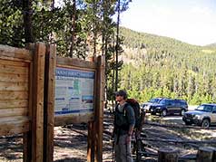
Above:
After a time check at the trailhead, we took a quick peak at the
map, and off we go! |
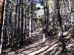
Above: Continuing to climb through the first leg of the trail. |
 |
 |
|
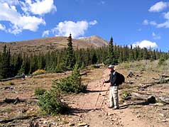
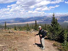
Above: You briefly enter a clearing prior to emerging above the
treeline, just long enough to catch a glimpse of what is in
store for you... |
Above: Emerging above treeline (at approx. 11,900 ft. looking
back towards Leadville). Still more than a 2 miles and 2,500
vertical feet to the summit!. |
|
|
|
|
 |
You've done the easy part, now the fun begins!
It's a long trek towards the peak. We were hit by pretty strong
gusts of wind from this point forward. The wind-chill forced us to
stop and gear up with gloves, thin fleece and windbreakers. Also a
good place to take a small break and re-hydrate. This mountain will
certainly test your will and desire to conquer it's summit.
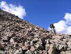
Around 13,000' the trail gets steeper as you
cross to the right of the false summit. Here its a pretty good pull
as you scramble up steep talus. (see photo on left.) But this is
also a great time to stop to soak in the scenery. This mountain is
just plain immense. To your right you'll have great views of Mt.
Massive, look behind you and you will see the town of Leadville way
off in the distance. You'll also notice that the forest from which
you emerged is a long, long way back...
Enough of the sight seeing, we decide to press
onward. We are having a ton of fun up here, but we have a summit to
conquer!
It's about here your will and desire are
challenged for the last time; you may experience a final moment of
discouragement at this point where after climbing some steep
sections to about 13,900' you still can't see the true summit!!
Here at least, the worst (steepest) is over and you can feel
confident that the summit is within your grasp. You can clearly
begin to feel the effect of thin air and altitude at this point, but
hopefully your body will begin to enjoy small rush of adrenalin as
you near the top. No turning back here!
Finally, the summit is ours. Be sure to savor
the moments at the top........it is a long slog back! |
 |
|
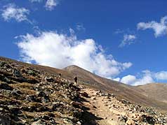
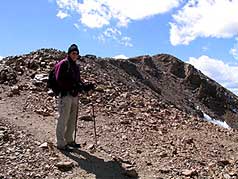
Above:
Its a loooong trek to the summit. Here you are probably at about
12,000ft. |
Above: continuing onward! And of course, what you see ahead is a
false summit! |
 |
 |
|
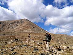
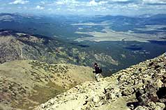
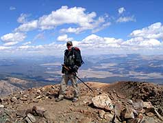
Above:
A SCE hiker pauses for a photo as before continuing to climb up
the talus to on the right side of the false summit. You're
really looking up here. |
Above:
Incredible views! This is looking out over Mt. Massive as we
begin our climb up the right side of the false summit. |
 |
 |
|
Above:
It just keeps getting steeper. I take a look back in time to and
snap a photo of Another SCE hiker climbing up out of the
talus. |
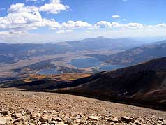
Above: A view back South, looking out over the twin lakes. |
 |
 |
|
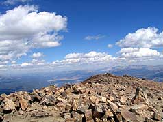
Above:
The most difficult part is now behind us, but the summit is
still not quite in view. Its hiding just up around this bend! |
Above:
Finally at the top. (14,433ft.) This is looking back South over
Lake Turquoise and the town of Leadville. |
|
|
|
|
 |

If you reach the summit,
then
Summit County Explorer's
"I LIKE TO BE ON TOP"
T-shirt and gear is well deserved. Check it out by clicking
the logo above. |
 |
|
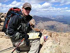
Above:
On top the highest peak in Colorado! Not exactly t-shirt
weather, its about 36 degrees with strong gusty winds. |
Above:
I stop to pose with a small American Flag and a sign reading:
Mt. Elbert / 14,433 ft / Sept. 2004 |
|
|
|
|
|
|
|
|
|
|
|
|
|
|

|
beginner
|
|
intermediate
|
|
advanced
|
|
|
|
Black
Powder Pass
|
|
Mohawk
Lake
|
|
Quandary
Peak
14,265' |
|
|
|
Lily
Pad
|
|
Chihuahua
Gulch
|
|
Lincoln & Bross
14,291' / 14,177' |
|
|
|
St.
John's
|
|
Mt.
Royal
|
|
Bierstadt Peak
14,060' |
|
|
|
Mayflower Gulch |
|
Wheeler Lakes |
|
Willow & Salmon Lakes |
|
|
|
Loveland Pass |
|
Radical Hill Trail |
|
Upper Crystal Lake |
|
|
|
Salt Lick
Trail |
|
McCullough Gulch |
|
Gray's & Torrey's
14,278' / 14,267' |
|
|
|
Mesa
Cortina Trail |
|
Mt.
Sniktau |
|
Mt. Democrat
14,152' |
|
|
|
St. Mary's Glacier |
|
North
Ten Mile Trail |
|
Mt.
Victoria |
|
|
|
Sally Barber Mine |
|
Willow
Falls |
|
Mt.
Elbert
14,433' |
|
|
|
Oro
Grande Trail |
|
Eaglesmere Lakes |
|
Buffalo Mountain
12,777' |
|
|
|
Meadow Creek-Salt Lick |
|
Mosquito Pass |
|
Eccles Pass |
|
|
|
Shrine Mountain
Trail |
|
Webster Pass |
|
Mt. Huron 14,003' |
|
|
|
Ptarmigan Trail |
|
Ptarmigan via Wilder Gulch |
|
|
|
|
|
Peaks Tr. Barton Gulch |
|
Wheeler
Lake - Park County |
|
|
|
|
|
Hoosier Pass Loop |
|
Lenawee
Trail |
|
|
|
|
|
Spruce Creek Loop |
NEW! |
Nightmare on Baldy Mine |
|
|
|
|
NEW! |
Tenderfoot
Mountain Trail |
|
|
|
|
|
|
|
Did You find our FREE trail descriptions useful?
Please donate a buck or
two.
We appreciate your support! |
 |
|
|
|
|
|
|
|
|
|
|
|
|
|


