|

|
 |
|
Below:
As you begin your ascent you can see the first two false summits
on
the left. You must cross over these before the third, steep
summit becomes visible. |
|
|

Check out Summit County Explorer's
"I LIKE TO BE ON TOP"
T-shirt and gear!
Click logo above
|
|
|
The first section of the trail is clearly visible as it ascends
the
spine of the ridge leading to the first summit. Here you will
find
huge cairns that serve as wind forts so you may pause and derive
some
satisfaction knowing that most of your elevation gain is behind
you.
At this first summit you will turn left (north) and overtake two
more
summits before the final one comes into view. These are pleasant
rock scrambles that lead to the final, somewhat steeper summit.
Everywhere you look spectacular views abound!
|
 |
 |
Be sure to spot Gray's and Torrey's off to the southeast.
(bottom left photo)
Turn around for a bird's eye view of
the Eisenhower tunnel! (bottom right image)
Note the ski trails at Arapahoe Basin,
Keystone, Breckenridge and Loveland. |
 |
|
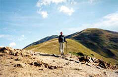
Above:
This
photo shows the true summit of Sniktau does NOT come into view
until you reach the top of the second false summit. |
Above: Wind shelters at the top of the first summit. Most of
your elevation gain is behind you at this point. |
|
|
|
|
 |
Use National Geographic's Trails
Illustrated Map of "Idaho Springs, Georgetown and Loveland Pass"
to help spot other landmarks.
A truly 'energizing" hike, anyone who summits Mt. Sniktau will quickly discover why Summit
County Explorers "Like to be on TopTM"! |
 |
|
Left: At the top of Sniktau's summit, Grays peak in the
background. |
Above: This is a shot looking out over the Eisenhower tunnel to
the Gore Range. |
|
|
|
|
|
|
|
|
|
|

|
beginner
|
|
intermediate
|
|
advanced
|
|
|
|
Black
Powder Pass
|
|
Mohawk
Lake
|
|
Quandary
Peak
14,265' |
|
|
|
Lily
Pad
|
|
Chihuahua
Gulch
|
|
Lincoln & Bross
14,291' / 14,177' |
|
|
|
St.
John's
|
|
Mt.
Royal
|
|
Bierstadt Peak
14,060' |
|
|
|
Mayflower Gulch |
|
Wheeler Lakes |
|
Willow & Salmon Lakes |
|
|
|
Loveland Pass |
|
Radical Hill Trail |
|
Upper Crystal Lake |
|
|
|
Salt Lick
Trail |
|
McCullough Gulch |
|
Gray's & Torrey's
14,278' / 14,267' |
|
|
|
Mesa
Cortina Trail |
|
Mt.
Sniktau |
|
Mt. Democrat
14,152' |
|
|
|
St. Mary's Glacier |
|
North
Ten Mile Trail |
|
Mt.
Victoria |
|
|
|
Sally Barber Mine |
|
Willow
Falls |
|
Mt.
Elbert
14,433' |
|
|
|
Oro
Grande Trail |
|
Eaglesmere Lakes |
|
Buffalo Mountain
12,777' |
|
|
|
Meadow Creek-Salt Lick |
|
Mosquito Pass |
|
Eccles Pass |
|
|
|
Shrine Mountain
Trail |
|
Webster Pass |
|
Mt. Huron 14,003' |
|
|
|
Ptarmigan Trail |
|
Ptarmigan via Wilder Gulch |
|
|
|
|
|
Peaks Tr. Barton Gulch |
|
Wheeler
Lake - Park County |
|
|
|
|
|
Hoosier Pass Loop |
|
Lenawee
Trail |
|
|
|
|
|
Spruce Creek Loop |
NEW! |
Nightmare on Baldy Mine |
|
|
|
|
NEW! |
Tenderfoot
Mountain Trail |
|
|
|
|
|
|
|
Did You find our FREE trail descriptions useful?
Please donate a buck or
two.
We appreciate your support! |
 |
|
|
|
|
|
|
|
|
|
|
|
|
|